
Riverina
Bureau warns of possible ‘life-threatening flash flooding’ as rain ramps up
A SEVERE weather warning for locally intense rainfall with the potential to cause dangerous and life-threatening flash flooding has been issued for parts of the Riverina, as a slow-moving inland system pushes into New South Wales.
The Bureau of Meteorology (BoM) says tropical moisture is increasing on the eastern flank of a low pressure system over South Australia, sustaining a broad rain band with isolated thunderstorms.
The low has lingered over central Australia for much of the week, delivering flooding rain to the parched outback, with tropical moisture now extending into southern and south-eastern Australia as the system gradually slides south.
BoM says a trough is expected to extend from the system and push into the far south-west of NSW tonight, lifting rain and thunderstorm activity and sharply increasing the risk of heavy falls.
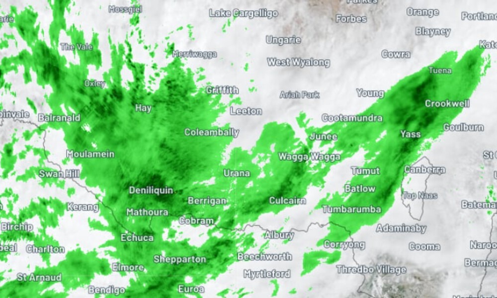
Under the current warning, six-hourly rainfall totals of 40–70mm are likely across south-western parts of the Riverina, Lower Western and Upper Western districts, with the risk becoming more likely overnight.
Thunderstorms may also produce locally intense bursts, with six-hourly totals of 70–100mm possible, creating conditions for sudden, fast-moving runoff and flash flooding that can develop with little warning.
“Locally, intense rainfall which may lead to dangerous and life-threatening flash flooding is possible throughout the warning area with thunderstorms, however is most likely about the far southern Lower Western and southwestern Riverina from later tonight,” the Bureau said.
Locations flagged as likely to be affected include Deniliquin, Hay, Balranald, Wentworth, Menindee and Broken Hill, with the warning area spanning large parts of the south-west and far west of the state.
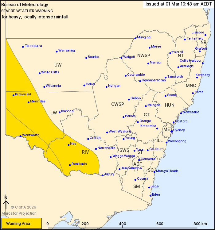
Severe weather warning issued at 10:48 am Sunday, 1 March 2026 | Source: Bureau of Meteorology
The warning coincides with a Flood Watch covering parts of far western NSW and the Lower Murrumbidgee River catchment, with authorities warning road access may be impacted and some communities could become isolated in the days ahead, depending on where the heaviest rainfall sets up.
The Bureau says catchments across parts of the Flood Watch area have already become wetter after recent rainfall, meaning additional falls could more quickly translate into creek and river rises, localised flooding and overland inundation.
While the renewed rain threat is welcome across the drought-affected region, short, storm-driven deluges can run off quickly—often eroding topsoil and pooling in low-lying areas—rather than soaking deeply into the ground where it’s most useful for longer-term recovery.
With thunderstorms possible, the greatest risk is not necessarily the daily total, but how much falls in a short window—the kind of rainfall that can turn dry creek beds into torrents and cut rural roads within minutes.
Rain and thunderstorm activity is expected to expand and shift east on Monday as the trough progresses, with widespread falls of 20–50mm forecast across the Riverina, South West Slopes and Snowy Mountains.
This includes Junee, Wagga, Narrandera, Cootamundra, Gundagai, Young, Tumut, Tumbarumba and surrounds, with the Bureau warning the warning zone may be extended if conditions change or the focus of the heaviest falls shifts.
Residents across the warning and watch areas are urged to monitor official updates and avoid unnecessary travel, particularly on rural and low-lying roads that can become impassable quickly.
The advice remains clear: never drive, walk or swim through floodwater.
For storm and flood assistance, contact the NSW SES on 132 500.
In a life-threatening emergency, call Triple Zero (000).


Pair charged after police car rammed, officer injured in Junee pursuit

Bureau warns of possible ‘life-threatening flash flooding’ as rain ramps up

Police probe alleged fraud at Junee pub